
Blenheim Boulevard Multimodal Improvements
Consultation has concluded. Utility relocation began in fall 2025, and construction is scheduled to proceed in 2026.
Project information is available on the city website.
Sept. 3, 2025, UPDATE: Washington Gas will begin relocating gas mains in various locations along the corridor starting Sept. 4. The work will continue through March 2026. Lane closures and detours are expected. If you have questions or concerns, please contact Washington Gas project manager Daniel Urrea at 703-750-4654 ext. 7, urrea.daniel@washgas.com, or Sunny Sarna, City of Fairfax transportation capital project manager, at 703-273-3067, sunny.sarna@fairfaxva.gov.
###
April 24, 2025, UPDATE: Utility relocation will begin in June. Trees at Fairfax High School have been marked for removal.
Blenheim Boulevard is a special place within Fairfax City. There are a variety of land uses along the corridor including three schools, the city’s public library, Sherwood Community Center, the police station, Van Dyck Park, churches, Historic Blenheim, and multiple residential neighborhoods. Commercial districts anchor both ends of the boulevard at Fairfax Circle and Old Town Fairfax.
The corridor is already multimodal in nature, which means there are multiple ways people use to get around, including driving, CUE Bus, walking, biking, and riding scooters. However, there is tremendous opportunity to improve the look, feel, safety, and function of the entire corridor.
In 2015, the city completed a conceptual plan for Blenheim Boulevard (formerly known as Old Lee Highway). Conceptual planning took about six months and included extensive public involvement. The result was a recommended concept for the corridor that includes separated bicycle lanes, upgraded pedestrian and transit amenities, and improved lighting, landscaping, and buffering. On Nov. 9, 2021, City Council adopted a resolution to approve the major design features of the project.
The most recent plans were presented to City Council during a public hearing on June 13, 2023. View the presentation.
Cost and Funding
The estimated project cost is $30.4 million. Funding sources include state revenue sharing ($10 million), regional Northern Virginia Transportation Authority funding ($13 million), and the city’s commercial and industrial tax ($2 million) – a fund dedicated to increasing transportation capacity. Construction is tentatively scheduled to start in 2026.

We have been in the Daniel's run neighborhood for 5 years now and we can't wait for the Multimodal to be completed. the final rendition of the project is beautiful, and the enhancements like flashing lights to cross the streets and a dedicated bike lane, are great additions. I hope the plans include planting lots of flowering trees on both sides of the new street. could you imagine how beautiful it will looks with flowering tress all along the corridor?
we very much welcome the multimodal.
I'm mostly excited for my kids to have a safer trip to high school. I'm also excited to safely access Fairfax Circle and the Cross County Trail on bike/foot, for the safety that comes with better street lighting and for a new and covered bus stop at the end of my street. It definitely sucks to lose the street trees to accommodate this, but I believe that the benefits outweigh the cost in this case. Besides, the street trees can be replanted (much better there than in the woods!) and this project removes almost an acre of impervious surfaces which will reduce runoff into Daniels Run and the Accotink.
My apologies for the redundant post.
Is there an objective way to measure the public benefit that will be received in return for the public investment in the planned bicycle track?
As of the most recent (June 2023) public hearing on this project posted on the City’s Engage web site, there was a discussion about placing counters to collect data on bike ridership prior to its construction, and there was also a discussion about conducting a survey to try to identify who will ride bikes on it once it has been constructed. Answers to those questions would be germane if this project were contemplated as a recreational facility. This bike track, though, has been promoted from the outset and funded as a transportation project, for the specific purpose of getting people to ride bicycles instead of cars, thereby reducing carbon emissions and motor vehicle congestion. As such, the public benefit and value of the facility in accomplishing that purpose is better measured not by bike-ridership data or projections, but as a function of motor-vehicle miles not driven.
1. Available Facts
I have not seen that data or projections or any quantification of the vehicular miles that will be obviated by the bike track’s construction has been requested or offered by anyone, likely due to the challenge in collecting and analyzing it. Hard data would probably be impossible to generate in advance of the project’s construction and nearly as difficult to collect once it is up and running. Even without such information, though, there are three known data points which I believe can be helpful in approximating the miles not driven because of the bike track and the corresponding public cost. They include the following facts:
1. The project is approximately 1.5 miles in length.
2. As of the most recent report by traffic engineers on the City’s Engage web site, the subject portion of Blenheim Boulevard roadway carried approximately 13,000 vehicles per day (in 2018).
3. The most recent cost estimate for the project in June 2023 is $30.4 million and probably increasing due to the recent inflation. Amortized over 30 years, the annualized cost of the bike track at that total cost without interest would be slightly more than $1 million, not including maintenance.
2. Formula and Table
The relative imprecision of the second data point for this inquiry may be noted here: residents of the neighborhoods along Blenheim Boulevard account for some unknown portion of the daily trip count, and their trips would typically be in or out and therefore not travel the entire length of the project’s 1.5-mile length. Similarly, any number of trips in the daily count may be visitors to those neighborhoods and they similarly may not travel the entire length of the project roadway.
Even without knowing the number or extent of local trips, the minimum annual cost of the facility can be determined. First, assume as a best-case scenario and upper use-limit that each of the 13,000 daily motor vehicle trips traverses the entire length of the project. In that case, 13,000 car-trips per day x 1.5 miles = 19,500 car-miles per day x 365 days per year = 7,117,500 car-miles per year. Second, assume as a best-case scenario that each driver in those 13,000 trips were to park the car and switch to a bicycle. The approximate annualized minimum cost of the bike-track could then be expressed as:
$1,000,000 ÷ 7,117,500 car-miles = $.14 per car-mile not driven in that year.
Consider this minimum cost/best-case scenario in comparison to other examples ranging down to a worst-case scenario, as shown in the following table:
Switch Rate Annualized Public Cost
13,000 trips 100% $1 million ÷ 7,117,500 car-miles = $0.14 per car-mile not driven
6,500 trips 50% $1 million ÷ 3,558,750 car-miles = $0.28 per car-mile not driven
2,600 trips 20% $1 million ÷ 1,423,500 car-miles = $0.70 per car-mile not driven
1,300 trips 10% $1 million ÷ 711,750 car-miles = $1.40 per car-mile not driven
130 trips 1% $1 million ÷ 71,175 car-miles = $14.05 per car-mile not driven
13 trips .1% $1 million ÷ 7,117.5 car-miles = $140.50 per car-mile not driven
1.3 trips .01% $1 million ÷ 711.75 car-miles = $1,405.00 per car-mile not driven
1 trip .007672% $1 million ÷ 547.5 car-miles = $1,826.48 per car-mile not driven
---------------------------------------------------------------------------------------------
Because the trip length is 1.5 miles, the annualized cost of the single trip-per-day in the last example would be $2,739.72 per trip. This last scenario sets an upper limit for the cost of the project per car-trip not driven, just as the first example establishes a minimum cost of $.21 per car-trip not driven where the switch-rate is 100%.
Consideration of the switch-rate table from the bottom up is instructive: If only one motorist per day parked the car and used the bike track, the public cost for that year would be almost $3,000 per motor-vehicle trip not taken. If just one percent of motorists parked and rode, the annualized public cost would be significantly lower, at under $30 per trip. If 50% of the motorists parked and rode each day, the annualized public cost would be $.28 per mile and $.42 per trip. Even with updated data on cost and vehicular trip-count (see discussion below), a similar progression in savings will result, increasing sharply at first and then leveling off.
To the extent the rate at which drivers in the future opt for bicycles instead of cars can be predicted, guessed, or hoped or wished for, an estimate of the annualized cost per car-mile not driven may thus be calculated with the formula recited above or interpolated from the values in the table.
3. Need for New Data
Even before the bicycle track is built, this formula would benefit from more current estimates of both project cost and car-trip counts, as well as estimates for maintenance and interest costs, if ascertainable. The updated data may then be used with this formula or some variation of it to evaluate more accurately the cost and value of the bike track.
Three factors will increase the annualized cost of the bike track as calculated here, once they are known: (1) the increase, by an as-yet unknown amount, of the eventual cost to construct the project beyond the current $30.4 million amount; (2) interest costs, if any; and (3) maintenance costs. There may be other factors that would increase the cost, such as installation of traffic signals, or city liability to persons injured on the bike track.
As an offset to the cost-increasing factors, there is at least one factor that should act to decrease the annualized cost of the project: the increase in potential motor vehicle trips resulting from population increase and increased demand for movement through the Blenheim Boulevard corridor. The 2018 trip data is now seven years old, and to the extent the daily trip count for motor vehicles on Blenheim Boulevard has increased and will continue to increase, the cost of the bike track per mile not driven as computed by this model would decrease, ceteris paribus.
4. Implications
None of the preceding analysis considers the real-life use-experience of a bicycle track facility such as this one. Once the bike track is up and running, and as more and more drivers trade their cars for bicycles, there will be more and more bicyclists wanting to use the bike track. At some point, they will be more than a minor annoyance to the neighborhood, particularly on the Country Club Hills side. More importantly, at some point, increased usage of the bike track will raise issues of bicycle-traffic congestion and safety, particularly when usage is concentrated during morning and evening commutes. The specific thresholds where congestion and safety become issues have not been explored here but would be a worthwhile subject of study before construction begins.
If bicycle-traffic congestion and safety issues limit usage and thereby cap the switch-rate from car to bicycle, then the annualized cost of the facility would be floored at that limit and may never become economically feasible, no matter how much the population of potential users increases.
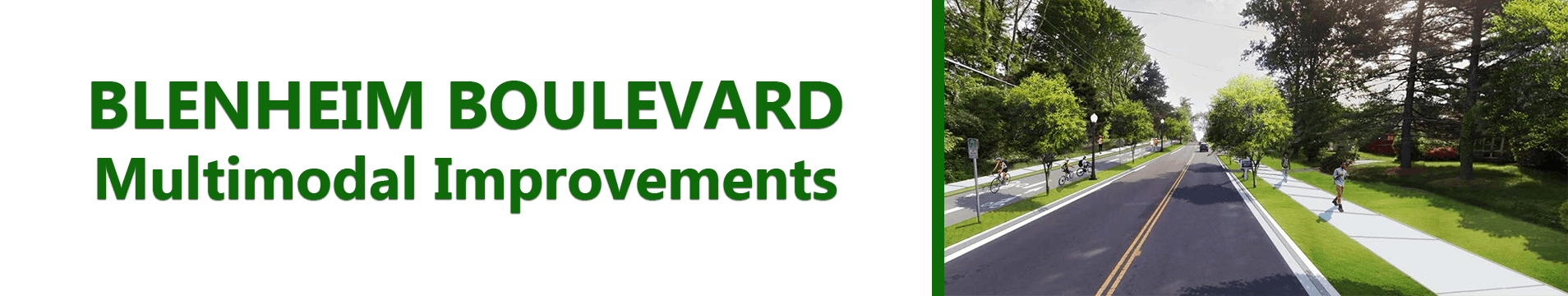
Blenheim Boulevard before the bike track is built comprises one vehicular lane in each direction, a pedestrian sidewalk on the south side, and a shared-use path on the north side, with overhead utility wires running the length of the project.
Blenheim Boulevard once the project is completed will comprise a single vehicular lane in each direction, a pedestrian sidewalk on the south side and the bicycle track on the north side. And it will still have overhead utility wires running the entire length. Plus ca change, plus c’est la meme chose.
Is there an objective way to measure the public benefit that will be received in return for the public investment in the planned bicycle track?
As of the most recent (June 2023) public hearing on this project posted on the City’s Engage web site, there was a discussion about placing counters to collect data on bike ridership prior to its construction, and there was also a discussion about conducting a survey to try to identify who will ride bikes on it once it has been constructed. Answers to those questions would be germane if this project were contemplated as a recreational facility. This bike track, though, has been promoted from the outset and funded as a transportation project, for the specific purpose of getting people to ride bicycles instead of cars, thereby reducing carbon emissions and motor vehicle congestion. As such, the public benefit and value of the facility in accomplishing that purpose is better measured not by bike-ridership data or projections, but as a function of motor-vehicle miles not driven.
1. Available Facts
I have not seen that data or projections or any quantification of the vehicular miles that will be obviated by the bike track’s construction has been requested or offered by anyone, likely due to the challenge in collecting and analyzing it. Hard data would probably be impossible to generate in advance of the project’s construction and nearly as difficult to collect once it is up and running. Even without such information, though, there are three known data points which I believe can be helpful in approximating the miles not driven because of the bike track and the corresponding public cost. They include the following facts:
1. The project is approximately 1.5 miles in length.
2. As of the most recent report by traffic engineers on the City’s Engage web site, the subject portion of Blenheim Boulevard roadway carried approximately 13,000 vehicles per day (in 2018).
3. The most recent cost estimate for the project in June 2023 is $30.4 million and probably increasing due to the recent inflation. Amortized over 30 years, the annualized cost of the bike track at that total cost without interest would be slightly more than $1 million, not including maintenance.
2. Formula and Table
The relative imprecision of the second data point for this inquiry may be noted here: residents of the neighborhoods along Blenheim Boulevard account for some unknown portion of the daily trip count, and their trips would typically be in or out and therefore not travel the entire length of the project’s 1.5-mile length. Similarly, any number of trips in the daily count may be visitors to those neighborhoods and they similarly may not travel the entire length of the project roadway.
Even without knowing the number or extent of local trips, the minimum annual cost of the facility can be determined. First, assume as a best-case scenario and upper use-limit that each of the 13,000 daily motor vehicle trips traverses the entire length of the project. In that case, 13,000 car-trips per day x 1.5 miles = 19,500 car-miles per day x 365 days per year = 7,117,500 car-miles per year. Second, assume as a best-case scenario that each driver in those 13,000 trips were to park the car and switch to a bicycle. The approximate annualized minimum cost of the bike-track could then be expressed as:
$1,000,000 ÷ 7,117,500 car-miles = $.14 per car-mile not driven in that year.
Consider this minimum cost/best-case scenario in comparison to other examples ranging down to a worst-case scenario, as shown in the following table:
Switch Rate Annualized Public Cost
13,000 trips 100% $1 million ÷ 7,117,500 car-miles = $0.14 per car-mile not driven
6,500 trips 50% $1 million ÷ 3,558,750 car-miles = $0.28 per car-mile not driven
2,600 trips 20% $1 million ÷ 1,423,500 car-miles = $0.70 per car-mile not driven
1,300 trips 10% $1 million ÷ 711,750 car-miles = $1.40 per car-mile not driven
130 trips 1% $1 million ÷ 71,175 car-miles = $14.05 per car-mile not driven
13 trips .1% $1 million ÷ 7,117.5 car-miles = $140.50 per car-mile not driven
1.3 trips .01% $1 million ÷ 711.75 car-miles = $1,405.00 per car-mile not driven
1 trip .007672% $1 million ÷ 547.5 car-miles = $1,826.48 per car-mile not driven
---------------------------------------------------------------------------------------------
Because the trip length is 1.5 miles, the annualized cost of the single trip-per-day in the last example would be $2,739.72 per trip. This last scenario sets an upper limit for the cost of the project per car-trip not driven, just as the first example establishes a minimum cost of $.21 per car-trip not driven where the switch-rate is 100%.
Consideration of the switch-rate table from the bottom up is instructive: If only one motorist per day parked the car and used the bike track, the public cost for that year would be almost $3,000 per motor-vehicle trip not taken. If just one percent of motorists parked and rode, the annualized public cost would be significantly lower, at under $30 per trip. If 50% of the motorists parked and rode each day, the annualized public cost would be $.28 per mile and $.42 per trip. Even with updated data on cost and vehicular trip-count (see discussion below), a similar progression in savings will result, increasing sharply at first and then leveling off.
To the extent the rate at which drivers in the future opt for bicycles instead of cars can be predicted, guessed, or hoped or wished for, an estimate of the annualized cost per car-mile not driven may thus be calculated with the formula recited above or interpolated from the values in the table.
3. Need for New Data
Even before the bicycle track is built, this formula would benefit from more current estimates of both project cost and car-trip counts, as well as estimates for maintenance and interest costs, if ascertainable. The updated data may then be used with this formula or some variation of it to evaluate more accurately the cost and value of the bike track.
Three factors will increase the annualized cost of the bike track as calculated here, once they are known: (1) the increase, by an as-yet unknown amount, of the eventual cost to construct the project beyond the current $30.4 million amount; (2) interest costs, if any; and (3) maintenance costs. There may be other factors that would increase the cost, such as installation of traffic signals, or city liability to persons injured on the bike track.
As an offset to the cost-increasing factors, there is at least one factor that should act to decrease the annualized cost of the project: the increase in potential motor vehicle trips resulting from population increase and increased demand for movement through the Blenheim Boulevard corridor. The 2018 trip data is now seven years old, and to the extent the daily trip count for motor vehicles on Blenheim Boulevard has increased and will continue to increase, the cost of the bike track per mile not driven as computed by this model would decrease, ceteris paribus.
4. Implications
None of the preceding analysis considers the real-life use-experience of a bicycle track facility such as this one. Once the bike track is up and running, and as more and more drivers trade their cars for bicycles, there will be more and more bicyclists wanting to use the bike track. At some point, they will be more than a minor annoyance to the neighborhood, particularly on the Country Club Hills side. More importantly, at some point, increased usage of the bike track will raise issues of bicycle-traffic congestion and safety, particularly when usage is concentrated during morning and evening commutes. The specific thresholds where congestion and safety become issues have not been explored here but would be a worthwhile subject of study before construction begins.
If bicycle-traffic congestion and safety issues limit usage and thereby cap the switch-rate from car to bicycle, then the annualized cost of the facility would be floored at that limit and may never become economically feasible, no matter how much the population of potential users increases.
Blenheim Boulevard before the bike track is built comprises one vehicular lane in each direction, a pedestrian sidewalk on the south side, and a shared-use path on the north side, with overhead utility wires running the length of the project.
Blenheim Boulevard once the project is completed will comprise a single vehicular lane in each direction, a pedestrian sidewalk on the south side and the bicycle track on the north side. And it will still have overhead utility wires running the entire length. Plus ca change, plus c’est la meme chose.
Hello everyone,
I have been living in Fairfax City for 10 years, and my family and I are eagerly looking forward to the changes being made to Blenheim Boulevard. We fully support this project.
We need a road where our children and pedestrians can travel safely. I truly have a hard time understanding those who oppose this project.
Wishing for this incredible plan to begin as soon as possible.
As Fairfax City residents, we stand with you.
Good luck!
I frequently bike from old town to the vienna metro. I would support any upgrade to bike lane infrastructure.
I frequently bike from old town to vienna metro along bleinheim. any upgrade to bike lane infrastructure would be much appreciated.
I think this will be a wonderful thing for Blenheim. While I think the ultimate solution would have been traffic circles, those were opposed by enough residents that the project was abandoned. This is a fair compromise. Narrowing Blenheim will reduce pedestrian risk (which should be a priority, as there are constantly children walking to/from school!). I love the overall plan and am excited about how it will benefit cyclists and pedestrians. I will say, I want more trees to be planted/replaced as not all the ones that are cut down are set to be replaced. Can't wait to get more updates. I didn't see anything about improved sidewalk along Army/Navy CC but that would also benefit residents.
Make the plan more understandable. 264 pages of architectural-type drawings makes it difficult to visualize the entire project. Get rid of the circles. The planners have apparently learned nothing from the disaster they created on University Drive (beyond Layton Hall when driving to Fairfax Blvd). The circles are road hazards that are bound to cause accidents and damage vehicles. Also, planners have in the Fairfax Circle suggested plans, REMOVED the circle which is what we call "conflicting guidance" for best practices. I would put this as a low-priority project. Drivers know Bleinheim Blvd is already marked for serious cyclists. For casual cyclists, the sidewalks and asphalt trail already in place works just fine to get you from Old Town to Fairfax High School. [I've ridden it many times with no issues]. There are higher priorities in the City, and given the fact Real Estate taxes (out of pocket for residents) have increase ~24% since 2021, and the City will pay ~$3M per year on interest servicing existing debt, perhaps its time for some fiscal leadership instead of finding new ways to spend money via studies, staff time, public hearings, and "nice-to-have" projects.
Statement: A difficult plan to assess due to the format presented. Comment: Stop with the traffic circles and "cute" traffic tricks. In other city plans you have Fairfax Circle being removed, but add circles in this plan? Have city planners been so oblivious to not see these frivolous features are dangerous? I suggest they drive down the University Drive toward Fairfax Boulevard and see the tire scuffs put on curbed obstacles they placed in an otherwise straight road during a prior foolish idea. Planners should be held liable for accidents resulting from these follies if they are going to continue proposing plans known to cause accidents and damage vehicles. The description (above) says this project "is tentatively scheduled to start in spring 2023." I haven't seen ANY work done on this project and its November 2024. Change the start date reference or update the status of this project.
Regarding hildiename’s Comment 4 below about the ugly 7’ wall: It doesn’t have to be that way. If the hillside between the homes and the street were carved back and replaced with a retaining wall and street-level sidewalk, a much less imposing privacy barrier would be needed above, pedestrians would have an easier walk below, and the whole area would look better driving by. Win-win-win.
Thank you for your question. The city will begin acquiring right-of-way along Blenheim Boulevard soon. We anticipate construction starting in fall 2025, with the relocation of utilities along the corridor. The project team presented an update to City Council during a design public hearing on June 13, 2023. You can view the slides on this page.
What is the current status of this project? Given all of the interventions on FairWoods Parkway, I am interested in learning what the plan is for Blenheim Boulevard, a much more heavily traveled roadway with speed issues.
For the past 50 years, we've designed streets to be car-centric which discouraged all other forms of moving around. As a result, we are car-dependent, the boulevard is noisy and too few people dare to cycle on it. Now is our chance to break this dependency and have some (still mostly) car, some bike and some pedestrian traffic. Also, I dont want to be chased by a dog when riding my bike, or my dog to chase a cyclist. Let's do this. // Patrick
With respect to the Blenheim bike path - it is increasingly evident that the current Mayor’s administration is continuously imposing controversial initiatives that starkly oppose the majority of our community's expressed desires. This pattern of disregard is glaringly apparent in the case of the proposed bike/pedestrian path.
Initially, the scheme was for a shared path catering to both pedestrians and bicyclists. However, with a lack of transparency, the plan has been covertly expanded to double its original size, creating separate dedicated lanes for both pedestrians and cyclists.
Furthermore, even before ground has been broken, the proposed project has already drastically exceeded its budget allocation, as disclosed in the last public budget update. This financial recklessness does not bode well for our city's economic health.
Another disheartening aspect of this project, however, is the destruction of our city's lush greenery and mature trees that have long stood as a gateway welcoming visitors. Additionally, there are unsettling indications that neighborhood property may be commandeered to accommodate this widely undesired path.
It seems that rolling back to a single lane would be better for the environment and budget.
Unfortunately, given the administration’s track record, it seems unlikely that our collective voices as residents will be taken into consideration. Nevertheless, the power to enact change remains in our hands. I urge all city residents to exercise to keep this in mind during the next election season.
Reading the comments for this project, I deduct that there are not too many CCH residents that approve the changes in this plan.
I served on the Taskforce Committee and when that was over, I felt the plan was reasonable and the cost was within the grant budget.
My bad that I did not keep up with the changes since then. As a CCH resident, I hear what many people are concerned about.
1. Changing the Old Post Rd entrance will not improve traffic. I agree that the left hand turn will be almost impossible. I also disagree that changing the width will improve safety. No accidents have occured on this street.
2. I am opposed to the wide bike trail. Residents have done our own survey's and I agree a bike trail is not necessary for the amount of traffic - why not widen the sidewalk and save 8' which will then
3. make it unessary to take out all the trees and it would give added space so that the neighbors on Old Post will not lose their fences and ,
4 I agree that the 7' wall will take away the openess of our subdivision (and it IS ugly) It will feel like we are in some barracks or such. We have a pretty subdivision and people should be able to see it from the highway -- and residents should be able to look out of their windows and see the Blvd.
5. I am opposed to spending more of my tax money for an additional 5M (or more) for this project. Cutting out some of these issues would bring it back on track in the proposed budget.
6. Having lived here for 58 years I have seen the plans for renovating Old Lee Highway about 3 times. Each time the residents opposed it. I agree that it is working fine with some improvements; however I am broad minded enough to agree with the plan that the City is looking to the future with these improvements.
The Council at the June 13 meeting had questions and concerns and asked for some verification on some of our issues. I would hope that this will be brought to the next meeting and that the residents of CCH will be notified.
3512 Old Post Rd.
I understand that a lot of my neighbors don't like change, but it seems like there's an unending list of issues that this project has tried to address and the solutions have be rejected over and over again. Speeding is a problem. Yet small, modern roundabouts - which would slow traffic and help people get out of our neighborhoods - were rejected. People are upset about losing trees - I am too - but we're also losing massive swaths of excess concrete along the eastbound side of the road and at Old Post. People complain about traffic, yet also complain about making a really unpleasant walking and bicycling experience nicer - which should help encourage more people to walk to schools, parks, churches, etc. It's also been demonstrated throughout the country time and again that tree-lined streets with good bike and pedestrian facilities (and people using them) helps slow traffic. What else helps? Narrowing the road. But now people want more turn lanes and parking for delivery vehicles which will add more pavement.
My point is, having an ugly road with unpleasant pedestrian crossings, substandard narrow bike facilities, a smattering of uncoordinated design elements, and substantial excess pavement is not a solution to any of these problems. The status quo is working, but not well. No one would intentionally design a road to look like this one does today. And yet, a proposal to bring it up to standard, add more trees, create a consistent, safer, and more pleasant experience for everyone, and make this gateway to our neighborhoods look nicer is just too much to handle. I don't get it.
So please, complete this project. It might be too late for roundabouts - which would have addressed the concerns everyone has now at Old Post - but it seems very unlikely that this project will do anything but make our neighborhoods nicer places to live.
This whole project is a terrible idea mainly because:
1. It's not needed
2. Causes the oss of trees/green space
3. Bottlenecking Old Post
As senior citizens and long time residents of Fairfax City, this disruption will likely prevent us from our plan to age in place.
Donna & Ken Dowd
I am totally opposed to the project. It is ill conceived and unnecessary. The problem is traffic and speeding on Blenheim Boulevard. The bike lanes and changing from the walking area will not address the problem. There needs to be more presentations and public hearings on the project especially now that there is a need to add 5 million additional funding. I do not think the public especially for those who are living in the affected areas of CCH are aware of the impact. There has been very poor education of the public and poor communication on the part of the council. None of the council live in the immediate area that will be impacted both on construction and resulting traffic issues. There needs to be improvement but not the current plan. We do not need to have exclusive bike lanes but do need better pedestrian walk ways. Finally, traffic in the corridor is abysmal and needs to be addressed. Better traffic control in the school areas and regulation of speed.