
Blenheim Boulevard Multimodal Improvements
Consultation has concluded. Utility relocation began in fall 2025, and construction is scheduled to proceed in 2026.
Project information is available on the city website.
Sept. 3, 2025, UPDATE: Washington Gas will begin relocating gas mains in various locations along the corridor starting Sept. 4. The work will continue through March 2026. Lane closures and detours are expected. If you have questions or concerns, please contact Washington Gas project manager Daniel Urrea at 703-750-4654 ext. 7, urrea.daniel@washgas.com, or Sunny Sarna, City of Fairfax transportation capital project manager, at 703-273-3067, sunny.sarna@fairfaxva.gov.
###
April 24, 2025, UPDATE: Utility relocation will begin in June. Trees at Fairfax High School have been marked for removal.
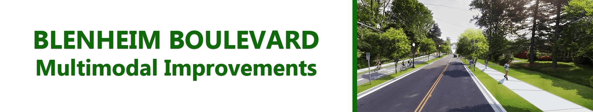
Blenheim Boulevard is a special place within Fairfax City. There are a variety of land uses along the corridor including three schools, the city’s public library, Sherwood Community Center, the police station, Van Dyck Park, churches, Historic Blenheim, and multiple residential neighborhoods. Commercial districts anchor both ends of the boulevard at Fairfax Circle and Old Town Fairfax.
The corridor is already multimodal in nature, which means there are multiple ways people use to get around, including driving, CUE Bus, walking, biking, and riding scooters. However, there is tremendous opportunity to improve the look, feel, safety, and function of the entire corridor.
In 2015, the city completed a conceptual plan for Blenheim Boulevard (formerly known as Old Lee Highway). Conceptual planning took about six months and included extensive public involvement. The result was a recommended concept for the corridor that includes separated bicycle lanes, upgraded pedestrian and transit amenities, and improved lighting, landscaping, and buffering. On Nov. 9, 2021, City Council adopted a resolution to approve the major design features of the project.
The most recent plans were presented to City Council during a public hearing on June 13, 2023. View the presentation.
Cost and Funding
The estimated project cost is $30.4 million. Funding sources include state revenue sharing ($10 million), regional Northern Virginia Transportation Authority funding ($13 million), and the city’s commercial and industrial tax ($2 million) – a fund dedicated to increasing transportation capacity. Construction is tentatively scheduled to start in 2026.

I want to applaud the city for taking feedback on this proposed development for seemingly YEARS. The outreach to the community has been fantastic. I am very excited for all the changes that are coming to Blenheim boulevard. I am not at all worried about a temporary construction inconvenience, nor a 5million dollar overage . I am also excited to see all of the new bikers who will have safe access to this road with the protected bike lanes. Many of which would not travel the route today. City Council, please remember that this road project will shape how the roadway will be used in years to come NOT HOW IT IS USED NOW. It also must support the people and development that will occur in the future. I’m glad that many residents have voiced their concerns but please understand that they are not long term planning for the city. The voices of the few do not speak for everyone.
I am not in support of the current plans for the Blenheim Boulevard Multimodal Improvement project. The 10 foot bike lane is unnecessary. Where is the data of how many “city residents” will be utilizing this bike lane? Blenheim Boulevard is main thoroughfare for the City, which has 3 schools, churches, police station, park, country club and a community center, all within the span of 2 miles. Traffic is very steady during peak rush hour and it can be difficult to exit the neighborhoods. The existing plan will make it even more challenging for the residents of Great Oaks, Country Club Hills and Daniels Run Woods to exit the neighborhoods. Any plans that narrow entrance/exit to the neighborhoods must be avoided. What is the plan for traffic during the construction period? Detouring traffic thru the neighborhoods is less than desirable and absolutely NO night construction! Also, I have attended community outreach informational meetings in the past and spoken with city planners and it seems like the majority of city residents have many of the same issues with the plans. The councils adoption of the current plans either did not explore resident’s concerns or just disregarded issues raised at these meetings. I am all for improvements, but not at the expense of residents who live in the communities along Blenheim Boulevard….less development and more green space. As tax payers and residents along Blenheim Boulevard our voice and concerns should take precedence.
I bought a home in CCH within the past year so I can't speak to all of the details of the proposed plans, but my overall impression is that perhaps there are better options to address some of the issues. The implementation of 3-4 way stops, speed humps or traffic lights to get folks to lower their speed. I also have serious concerns regarding what will happen when construction occurs. As someone else mentioned there are multiple schools and a church all within a mile or so radius on Old Lee Highway - will residents be able to come and go within a reasonable amount of time/what will the impact be on folks that live right off of Old Lee Highway? Finally, why exactly are we paying all this money for a bike lane - don't get me wrong, I bike, jog, walk and have for many years on multiple trails in this area, but the existing paths seem sufficient. Wouldn't money be better spend on adding lanes on both sides of Old Lee Highway to help alleviate the traffic issues when schools are in session? I think there needs to be more discussion/thought regarding this plan.
Turn lanes were flippantly added at the Public Hearing by a Council Member who eventually voted against the entire design because 8 people requested them. Adding these left turn lanes at the request of so few, while ignoring many, many more of the 300 CCH Residents who will now find it impossible to make a left hand turn out of our neighborhood. There are only 3 ways out of CCH for 300 residents. We will no longer have the ability to turn right without being stuck behind someone waiting to make a near impossible left out of our neighborhood. This plan was presented to us before knowing about the massive amount of development at either end of Blenheim Blvd. I would like to suggest adding a 4 way stop at Brookwood or Old Post to allow us to leave the neighborhood and our children to safely cross. This could possibly keep us from becoming a Blake Lane by breaking up the flow of traffic just enough to keep speeds a little more reasonable. I also ask that you honor our neighbor's request to not put up a 7 foot wall as she enjoys seeing the world go by.
I am Elva Card. I have lived at 3521 Old Post Road in Country Club Hills for 39 years. I have counted myself fortunate to live in such a lovely place, one where the local government is responsive to its citizens. But now I am very much concerned about some of the items in the Blenheim Boulevard Multimodal Improvement Plan.
Since there were only five of us from the local community who spoke at the hearing on June 13, the Council may be left with the impression that there is general agreement on the proposal. Actually, the reality is very different. At least here in Country Club Hills, most folks are not aware of the proposed changes. There have been several events to inform the public. I guess the planning has been going on for so long, we just sort of tuned it out. Obviously we should have been more alert. On the other hand, Hildie Carney, our representative in early planning sessions, was unaware of some features of the final plan. If Hildie was unaware, it’s not surprising that most of us were equally unaware.
The cost overrun is a concern. At the Council meeting on June 13, 2023, there was some discussion of ways to reduce the cost of the Blenheim Boulevard Multimodal Improvement Plan. Since the $30 million estimated cost exceeds the $25 million grants, reducing costs would seem to be a sound idea, one worthy of more consideration.
There are two proposed changes of special concern to me, items #15, #29 and #30. There are perhaps 300 homes here in Country Club Hills, with three exits to Blenheim Boulevard. The exit by Old Post Road is very wide. Last year the City installed new curbs and sidewalk improvement. That seemed very nice. But now there is a plan to reorganize this exit (Item #15). A justification is that it will “remove excess paved area.” But what to planners may seem like “excess paved area,” to those of us who live here is something quite different. It means that we will not be stuck behind a left turning vehicle when we want to make a right turn. I realize none of you on the Council will live with this problem. You don’t live in Country Club Hills. Most of the time, turning either left or right is easy, but there are times, when traffic is heavy, when losing our right hand turn lane will mean being stuck for a while. Cancelling item #15 would save some money.
As I studied the plan regarding our exit, I was stunned to find that my own property is in danger from the plan. In my own particular area, from Old Post Road down to Saint Leo’s, there are four properties with borders on Blenheim Boulevard. In the small black print, I saw that the Plan would remove our fences and replace them with a 7 foot high wall. (They call it a “fence,” but at 7 feet, solid unpainted wood, it is really a wall, and an ugly one at that.) This is item #29. Item #30 would continue the wall from the other side of Blenheim Historical Site to Brookwood Drive. For three of us on my block, the fence encloses and protects our dogs. We are greatly concerned about the safety of our dogs between the time our fences are taken down and a new barrier erected. My neighbor three doors down had some contact from the City about this plan, but neither I nor my next door neighbor had any idea that our fences were in danger. Our first choice on this issue is that our fences be left alone. But if we can’t have that, at least make the new barrier an attractive fence. (I see some rather attractive white fencing on the other side of Blenheim Blvd., in the new houses there.) Please do not take away the lovely openness of Blenheim Blvd. and replace it with the ugliness of the walls along I-66. And PLEASE coordinate with us about our dogs. Cancelling items #29 and #30 would be a great relief to us, and would save some money.
The plan has two options for the $5 million deficit: get another grant, and/or “Fund all or part with local funding.” I respectfully submit that trimming the cost of the plan would be a third alternative. I don’t know how much could be saved by deleting the plan for the exit and the plan for the wall, but it would be that much less that had to paid for “with local funding.”
Elva Card,
3521 Old Post Road
Dear Council Members,
I am submitting this email to you so that you have this directly. I am also submitting this to the City Engage Page.
I live at 10134 Spring Lake Terrace and have been a resident since April 1978.
Since the open house in September 2021, I have been concerned about the scope of the project. It is too big. I provided about 12 comments on what was presented. I watched the council meeting where the results of the open house was presented, and I felt that what was presented did not adequately include my comments. They may not have been able to read my comments because my handwriting is pretty bad. LOL.
The idea of multimodal transportation is a nice one and the project goals are good sounding. However, the space along Blenhim Blvd. does not support. The artist renditions look very nice. This picture on page 7 of the recent presentation is very beautiful. People are walking and bicycling with only one car shown. This usage of the boulevard as shown is not realistic. I recently walked to Ridge Avenue from Old Post Road and back at 1 pm on a weekday. The stream of cars is not continuous, but it is nearly continuous at times. There are breaks in the traffic are probably due to the sequence of the traffic lights. The flow of traffic was higher during my walk towards Ridge Avenue versus walking back to Old Post Road. One thing that I noticed was that the noise from the traffic was quite loud.
There are some improvements that can be made. I was standing at the stop sign at Old Post Road exiting from Country Club Hills when I took the following picture. You can barely see a car approaching from the left. Ths lack of visibility is a problem.
Inline image
There is a patch of the sidewalk along the slope across from the golf course that is uneven and has some gravel resulting in unsure footing. Councilmember Bates commented on his experience walking along Blenheim Blvd.
I have heard comments that the residents on Ridge Avenue have commented about traffic. I don't know if a roundabout is the answer to this problem along with the traffic speed. I can attest to the fact that cars following me down the slope along the golf course will move to the left hand lane when we get to Ridge Avenue to pass me at higher than the 30 mph speed limit. This happens about 75% of the time. I am usually going to go east on Rt 50. They may be going around the circle to other destinations.
Safety is one of the project goals. As a point of history for Old Lee Highway, there was a traffic accident resulting in a pedestrian death about 40 years ago. Old Lee Highway, which was Route 237 at the time, was 30 mph speed limit. The council got the route moved to Pickett Road.
I believe that the multimodal goal as stated is not practicable on this road. The transportation consultant has done an excellent job with designing and showing the impact of this multimodal goal. The goal in and of itself does not appear to be a good one with what the need is. Councilmember Ross did bring up an interesting point about scooter traffic in the future. Biking and walking will not increase in the future. The amount of vehicular traffic along this road does not make it a pleasurable activity. I think people will walk elsewhere. I frequently walk to Courthouse Plaza and the library but not on Blenheim Blvd.
Thank you for your attention,
William Fournier
Most of the design seems great. I'd like to suggest several things.
1. At Great Oaks Drive the South bound bus stop should be covered just like the North Bound side is covered.
2. Work to further reduce the cutting of trees between Lion Run and Ridge Rd.
3. If your not going to build a sidewalk on Blenheim Blvd along the Army Navy Country Club then why not leave the area on the opposite side of the street along the Great Oaks neighborhood alone too?
- I like the idea of a left hand turn lane northbound on Blenheim Blvd at Great Oaks Way.
- I also am in favor of a separate bike lane on most of Blenheim Blvd
Personally, I don't understand the push to redesign Blenheim Blvd. There are intersections/roads in the City that deserve more attention and that should take priority over this project. I understand that discussions are underway to improve the Eaton Place/123 intersection and I think that project should be a priority, especially when considering the price tag of the Blenheim project and utilizing $2 million of City resources. At best, I think the Blenheim project would offer only minimal improvements.
Additionally, I really don't understand the push for adding a traffic circle at Ridge Rd. People already have a hard enough time navigating Fairfax Circle and constructing another circle within a quarter of a mile doesn't make much sense to me.
If a bike lane is going to be installed, is the Daniel's Run Woods side of the road being considered for it's placement? Putting it on this side of the road might be safer for bikers trying to reach the Fairfax Connector trail that leads to the Vienna Metro Station
June 19, 2023
Dear Mayor Read
When you reached out to a small group of citizens in our neighborhood around a wood fire on a chilly evening, I was heartened by the excellent discussion that you led and pleased when you told us that you would make sure that an environmental assessment would be included in the analysis of every major project.
I agree that bike riding can be a healthy activity. But I don’t support the $30 million project that was discussed at Council the other evening. I would note that the City already has a trail in Daniel Runs Woods for both bikers and hikers that runs from the country club up to TJ Maxx in the shopping center at the Little River Turnpike. In addition there is a 17 mile multi use trail that can be accessed off of Blenheim Boulevard but is usually accessed at Mantua that is widely used by both bikers and hikers.
I know that you are not a voting member of the Council, but as Mayor I believe that you do have control over the City’s professional staff. Please direct them to perform an environmental assessment of the proposed $30 million project that would include an analysis of alternative means of achieving its objectives and submit it to the new Council for approval before any further steps are taken to implement it.
And with your impressive record for civic engagement, I would imagine that you would instruct the professional staff to put the assessment out for public comment and also to work far more proactively to solicit the views of the landowners who are directly affected.
Best Wishes
Jeff Burnam
3608 Parklane Road
Fairfax Virginia 22030
703 539 9509
Cc: Fairfax City Council Members
My comments are specifically about the Spring Lake Terrace/Old Post section of the project (slides 29 and 15 of the May 2023 Council Work Session)
Slide 29 - We are one of the four houses affected here. We do not wish to have a 7-ft privacy fence. We would appreciate working with the City to consider other options that won't have us feeling so closed in, which is not the 'feel' the project is seeking for residents. We also would appreciate the opportunity to install a gate in the fence. We exit our back gate to walk into town frequently and will be very disappointed to lose this access, which is the opposite of the goal of the project. Finally, we hope the City will work collaboratively with us when it is time for work to begin as we have dogs that enjoy the run of the backyard. If our current fence is removed without a new one going up immediately, this will cause us a hardship. Overall, I hope the Council and the City are willing to work collaboratively with us as our homes and our experience of Blenheim Blvd are directly impacted by this work.
Slide 15 - While we support narrowing the intersection, we request consideration of a right-turn lane from Old Post onto Blenheim Blvd so that cars do not have to wait behind those who are waiting to turn left.
Please consider the following comments:
1. One inexpensive way to enhance pedestrian and bicyclist safety would be to reduce the speed limit from 30 to 25 miles per hour. Vehicles, including trucks and buses, typically and frequently exceed the limit by up to 10 miles per hour, and even faster in the early morning hours before increasing traffic slows them down. If the limit were reduced from 30 to 25, it would take only a few (24 if my math is correct) more seconds to drive at the speed limit from Lion Run to the Sherwood Center. For most of us who live here, the time we are on Blenheim while on a trip in or out, in or from either direction, would usually take only a portion of that time. Only people who use our neighborhood as a cut-through would experience more than a minute’s increase in their commuting time, and only then if there is no other traffic to slow them down.
2. Pedestrian sidewalks should be approximately level, even if not always aligned, with the adjacent roadway. The “meandering sidewalks,” particularly the ones west of Heritage with their abrupt climbs, look like slapdash afterthoughts instead of integral components of a graceful boulevard. They are not picturesque. The sidewalks between St. Leo’s and Heritage Drive (both sides) should be at the same grade as the road, with retaining walls as needed. Beautiful new street trees, carefully selected by the tree experts, can replace whatever older trees need to be removed.
3. Plant shade trees wherever possible along the pedestrian sidewalks. Eliminate berry bushes that overhang and stain the sidewalks.
4. Use contrast-color paving for the centerline and elsewhere instead of unattractive yellow highway paint. Minimize highway paint and signage generally, especially the yellow/black cautionary signs, which should no longer be necessary. The boulevard is no longer a highway and no longer needs to be decorated like one.
5. The original recommendation for a rotary circle at Country Hill Road was based on the collective professional transportation planning and engineering analysis of the staff involved. There were some yard signs and commentary in opposition, and apparently it is not included in the current proposal. Has there been a change in the professional analysis? A rotary at Country Hill would improve traffic flow and reduce serious collisions. It could be an attractive “gateway” landmark to the residential middle portion of Blenheim Boulevard. For most of us, it would just be a slight jog in our ride, reminding us to drive at a safe speed.
6. Just as bicyclists desire protection from motor vehicles, pedestrians need to be protected from bicycles. There should be a pedestrian-only sidewalk on at least one side of each block, if not both. A shared-use path should not be a pedestrian’s only option on a major city street or boulevard.
7. Restore the undergrounding of overhead utility wires, for all the good reason it was a centerpiece of the original plan. If there are not enough funds, let’s bank and invest what we have, and let’s be patient and defer gratification until we can get the Blenheim Boulevard we want. If we are in a use-it-or-lose-it situation, then let’s spend what we have on safe, clean, and comfortable pedestrian sidewalks.
This project will have a significant impact during construction.
This road has two elementary schools on one end, a high school on the other, one of five largest Catholic parishes in the Diocese of Arlington, a public park, a golf course, and of course Route 50/29 on one side, and Route 236 on the other.
The citizens of these neighborhoods need assurances of construction schedules, road closures, and detours through the neighborhoods which will not prevent them from getting to and from school, church, or normal activities without significant delay or impediment.
Now that actual money is being spent on land acquisition, when will the citizens get to hear from the staff on how this massive project is going to be built? Lion Run is a parking lot at 745AM and 3PM. Blenheim Blvd backs up to Layton Hall Road and North Street during school drop offs at St. Leos and Daniels Run between 730 to 830AM, and traffic can backup to the golf course during the evening commute on Blenheim Blvd. Single lanes, alternate routes or detours during these periods may create safety hazards or simply may not accommodate traffic loads thereby impacting school start times, bus routes, student pick up or residents trying to get to baseball or swim practice.
It is time to have this discussion with the residents, churches, and school administrators so adequate preparations can be made or construction costs associated with staggered or limited construction schedules can be adequately estimated and included in project bid specifications and overall project schedules. The citizens deserve this level of transparency for such a large and controversial project.
The price of the project seems excessive as does all the "improvements" that need to be done. So many trees lost and will citizens use the "improvements" to validate the cost. I agree that sidewalks are important and should be more a part of the plan.
Tim Parmly
To summarize my views succinctly: this project 1) offers generally modest improvements in the Blenheim Boulevard corridor 2) at an unbelievably expensive price, both in money ($30 million) and in damage to the environment (the lives of nearly 200 mature trees, including many that currently provide shade for people on foot or bicycle). And 3) the corridor is already adequate, although not perfect, for "bicyclists of all ages".
Roundabouts are nice; protected bike lanes are nice; improved intersections are OK, although wider turning radii and improved visibility may perversely result in higher vehicle speeds, thus making the corridor less safe for bicyclists and pedestrians. But a cost of $30 million and 188 trees is simply unbelievable for light improvements to a 1.5 mile stretch of surface street with a single travel lane in each direction. That is a price that would be expected if the project were completely reconstructing several lane-miles of major urban interstate, not simply adding a roundabout and new paint markings on the pavement of a local arterial.
On a more qualitative (and personal) note, I enjoy bicycling around our city, especially with my 4-year-old son riding along. Aside from the 1/3 mile between Lion Run and Ridge Avenue, the corridor is already adequate for him and for other new bicyclists, and even on that stretch of street the typical vehicle speeds are low enough to make sharing the road surface safe for adults and older children.
Council should pause this project and take time to seriously reconsider which of its details have raised the price so unbelievably high. As a Certified Public Accountant with experience in the heavy civil construction industry, I'm happy to assist them in any way I can.
Can we understand what the visibility will be like for cars exiting the CCH neighborhood? The plans show that the intersections are moving closer to the roadway which is great. However I cannot tell with the addition of the turn lanes on Blenheim Boulevard how drivers exiting CCH will be able to see oncoming traffic in either direction. Is there a rendering where sight lines from the new proposed intersections will be? I don't want to have to pull into the bike lane or pedestrian path to see oncoming traffic just to exit the neighborhood if at all possible. We have to do this today and if we are improving the intersection it would be great to be able to clearly see oncoming traffic from the stop sign at the intersection.
I'd like to know if the Task Force on Homeless is talking to the Multimodel improvements team that is proposing "welcoming gathering areas and green spaces for individuals to congregate"
I would like to understand what the cost savings would be if instead of having a 10-foot, two-way separated bike lanes, the project instead included one bike lane attached to the road. I understand that staff is recommending getting rid of the sidewalk along the country club, but it would be better to save money on the bike path. Sidewalks are more important.